Newman Lake Traffic
NL Traffic Concerns
Trent/Starr Traffic Report Prepared by DOT
CLICK HERE to access the Trent Starr Traffic Report prepared by DOT. November 2024
Starr & Trent Intersection
David and Krista Schreiber recently (2021) purchased property north of Trent Avenue overlooking Newman Lake and access their property via Starr Road. They love their new location and living in Spokane County.
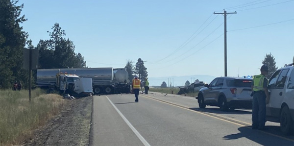
However, they have some concerns about safety in terms of accessing Trent Road. As I am sure you are aware, the Newman Lake community is land locked by Trent Road/ SR 290 and the Burlington Northern Rail line that runs along it. Our community cannot access essential services without crossing these two routes. Getting onto Trent can be difficult and recently we have observed a number of traffic incidents which is disturbing. Along with a recent train incident on Harvard and Trent.
They could use Newman Lake community members help as they are new to the area and don’t have the history of the roads or access management practices.
If you are interested in helping please read the information below and contact:
David Schreiber
david@uncleskunkle.com
or
Krista Schreiber
schreiberkrista@gmail.com
2021 Meetings & Communication
(most recent on top):
Meeting Notes: September 7, 2021
Newman Lake Traffic Update onto Trent
Attending: Mike Gribner, Regional Administrator Eastern Region Washington State Department of Transportation, Glenn Wagemann, WSDOT Eastern Region Traffic Engineering Manager,
Josh Kerns, Spokane County Commissioner, Mike Padden State Senator, Tom Stebbins Newman Lake Property Owners President, David Schreiber Newman Lake resident and NLPOA lead.
Glenn Wagemann opened the meeting with traffic statistics and a brief history of the traffic improvements that have been done in the past to Trent road to improve the safety. As mentioned in the past Glenn and Mike Gribner explained that the state currently does not have any plans to fund any improvements along Trent road at this time.
Glenn Introduced David Schreiber as a member of the Newman Lake community and NLPOA member with concerns about the traffic safety. He presented the following;
Purpose: Discuss the opportunity to create and fund a Newman-Otis 290 Safety Corridor.
Existing Safety issues experience by a daily user and resident:
• Right of Way cross traffic confusion at Idaho/290 and Starr/290 road intersections.
• Safe left turn visibility and judgement at Idaho/290 (55mph oncoming) and Starr/290 during peak hours and poor visibility weather.
• Train back up and safe crossing at Harvard/290.
• Gas station & post office entrance to 290 blind spot with semi-truck traffic.
• 290 west bound to Starr to make left turn blind spot from oncoming left turn traffic.
• Traffic has increase in the 1 year we have lived here and will only increase more as Idaho greater growth and Amazon gets up a going.
Benefits of a safer corridor
• Less accidents, more lives saved less cost on the community
• Property values increase more tax revenue
• More direct driving benefiting the environment
• Less stress on the community as a whole, the less stressed the community is the more likely they are to vote for their incumbent leaders.
Discussion afterwards evolved around the concept of a “Safety Corridor” and what qualified as one and the steps to getting one in place. Mike Gribner and Glenn Wagemann both agreed it would be the quickest and most economical approach to seeing safety improvements along Trent Road from Harvard road to Idaho Road. Senator Padden and Commissioner Kerns both acknowledged that development in the state of Idaho and with the new Amazon facility that the traffic impact on the Newman lake community would only continue. Tom Stebbins communicated that the community support for any type of safety improvements along Trent road would be very strong. As the meeting concluded Glenn Wagemann took ownership of starting the exploration process to designating Trent road from Harvard to Idaho as a safety corridor. Once Glenn has completed this process he will communicate back to David and Tom on the next steps for community involvement.
Look for more updates in the future from the Newman Lake Property Owners Association. For specific questions or thoughts please communicate with David Schreiber who leads this important effort at david@uncleskunkle.com.
From: David Schreiber
Sent: Thursday, August 5, 2021 2:51 PM
Subject: Newman Lake Community Traffic concerns PLEASE READ
Hello Glenn, Mike, Kevin and our Community Leaders,
Thank you very much for the extensive work in compiling the information regarding the traffic history and improvements to date for the Trent and Star road intersection. It is very useful. The information provided and the day to day traffic reality of Trent road, are obviously not in line. We would ask each of you to make a left hand turn on to Trent road from Star, Idaho, or Harvard roads at 4:22pm M-F, but that would not be a safe request and if anything happened to you we would feel responsible. Keep in mind it is summer and visibility is good, attempt that maneuver any other time of the year and the risk increases many fold. So why do we have a statistical picture that paints a somewhat safe road, and a reality that qualifies the road as an extreme sport? I believe it is because we are not asking the right questions to make a qualified decisions on how to make the road safer both today and in the future.
Here are some additional questions I believe we should be asking.
- Idaho Side. Trent Road becomes HWY 53 on the Idaho side just past the Idaho road intersection. Since Trent is a state road and not an interstate road the data provided is only looking west. We need to ask questions that looks both East and West. In order to do that, we need information from the State of Idaho and determine what impact it is having on our community traffic both today and in the future. QUESTIONS: Who is our liaison for this information? If the information provided shows extensive traffic growth currently and predicted in the future from the Idaho side, how will that impact the decision for a traffic safety solution on the Washington side?
- Semi-Truck Traffic. The information provided by Glenn did not address Semi-Truck Traffic on Trent road. In the year I have lived here I have watched the Truck traffic increase dramatically. Obviously increased truck traffic reduces the level of safety. QUESTIONS: What steps need to be taken to get the truck traffic information? What steps need to be taken to request increase the patrols and monitoring of the portable Weigh station at the Idaho road intersection? The state of Idaho frequently sets up their boarder check point and keeps an active boat check station. What would it take to coordinate this activity between the two states so that it is truly effective in both directions?
- Burlington Northern Rail line. We realize the rail line falls under other jurisdictions. That said, the impact the rail line has on the safety of traffic on Trent road is enormous. https://www.krem.com/article/traffic/train-versus-car-crash-in-otis-orchards/293-02756bdd-b82f-44cd-bfed-20232f83244e . Harvard road is the worst , especially around the 4 pm hour. QUESTIONS: How can we engage in a proactive conversation with Burlington Northern to reduce their rail traffic through the area during the 4 to 5pm hour and space their road crossings apart long enough so cars can have enough time to fully cross the track before an second train arrives? Can we set up train crossing timers to inform drivers prior to the arms closing that a train is coming? As locals we know that 3 lights on a train mean it is moving. Can we have signs that remind other drivers of this fact, since trains often park and it is hard to tell that they are moving? What studies have been done for rail over passes at Idaho and Harvard?
- Speed Limit. As the saying goes “Speed Kills”. QUESTIONS: Our first question is why is the speed limit on Trent Road is 55mph where it is a 2 lane road and 50mph where it is 4 lane road such as between Barker and Sullivan? How did they determine that reducing the speed to 45 in Moab/Newman Lake was the right speed, does traffic volume factor truck traffic? What is the cost/benefit to the community and the environment per each mile per hour the speed limit is raised or lowered?
- Out of the Box Safety Ideas. We appreciate the innovative safety precautions that have already been put in place, we can only imagine the issues today if they had not been. Here are some additional ideas as temporary fixes until a traffic solution can be enacted. QUESTION: What is the feasibility of these ideas?
- Place reverse speed detection signs along with safe turn markers on the road so that drives can anticipate if it is safe to turn left. During the winter months when visibility is poor it is hard to judge safe distances.
- Place oncoming directional traffic lights near intersection areas, if the light is green it indicates that cars are a safe distance at their current speed to enter the lane.
- Post a Sign at Star Road reminding drivers that oncoming traffic has the right of way. This may seem like common sense, but because of the angle of the intersection it leads to some confusion, especially with the turn lane.
- Many of us use the left turn into the post office as a safe left turn option at Star Road. Placing a similar type of U turn option at Idaho would work as well, there is plenty of room to make this type turn around. We do not believe Harvard offers this same option.
- Economic Impact: As our Real Estate community has verified placing a safe crossing into the Newman Lake community would increase property values and there for create a positive economic impact. QUESTIONS: Who do we contact to help us determine the amount of this impact? Does this help in the States decision to create a safe traffic solution?
- Environmental impact: All of us that live in the Newman Lake Community take longer alternative routes to avoid the unsafe driving conditions these intersections create. QUESTIONS: Does the environment have any impact on the state’s decision to create safer intersections? If so who do we need to contact to determine this impact?
- The Big Question. The Newman Lake community is unincorporated so we are dependent on our County and State community leaders to help us with issues such as these. QUESTION: As members of this community what do we need to do next, to make our safety a priority with Spokane County and The Eastern Region Washington State Department of Transportation? What ever it is that needs to be done, we will do it. Our lives are at stake, we cannot afford to lose another life in order to make a public safety change happen.
We realize we are asking a lot of questions here, however the more questions we ask the more accurate of a picture we can create to make informative decisions to move forward. The status quo is not an option. As community leaders we ask for your help in answering these questions. We as community members are willing to participate, we just need your help.
Thank you for your time and attention and all of your help up to this point.
Sincerely
David and Krista Schreiber
From: WSDOT
Sent: Wednesday, August 4, 2021 2:50 PM
To: David Schreiber
Subject: Newman Lake Community Traffic concerns
Hello David and Krista,
Welcome to Spokane County and the Newman Lake area. My name is Glenn Wagemann, WSDOT Eastern Region Traffic Engineering Manager, and I was asked by Mike Gribner to follow up on the commitment to provide crash data for the SR 290(Trent) and Star Rd intersection.
Later in this email, I’ll share some high-level crash information. However, because Federal law 23 United States Code (USC) Sections 148 and 409 governs use of the crash data you requested, you’ll need to file a public records request, which is easy. It is the policy of WSDOT to make crash data available to anyone who requests the data through the appropriate and applicable methods outlined below, and requires the requestor’s acceptance and acknowledgement of the data constraints per the state and federal laws governing access to the data. Depending upon the data requestor and the requestor’s purpose for requesting crash data, there are differing methods to obtain crash data. Since you are requesting a specific location, follow the steps in the second bullet below.
- WSDOT Crash Data Portal – This portal provides access to the general public to high-level summarized crash data by jurisdiction, year, and topic, such as drunk or distracted driving. The reports also contain summaries of the emphasis areas outlined in the Washington State Strategic Highway Safety Plan known as Target Zero. The crash data portal is found at the following link, WSDOT – Crash Data Portal (wa.gov)
- WSDOT Public Disclosure Request Center – If the requestor is a private citizen, attorney, member of the media, university employee, student, tribal member, or non-WSDOT consultant, the requestor must log into the WSDOT Public Disclosure Request Center to complete their request. Crash data is available through WSDOT’s public disclosure process found at the following link, WSDOT – Crash Data Request Form (wa.gov) .
Each year there are approximately 3700 collisions on WSDOT highways in Eastern Region (consisting of Stevens, Pend Oreille, Adams, Lincoln, Spokane, Ferry, and Whitman counties). Approximately 1200 of those collisions occur at intersections, with an average of around 20 serious injury collisions and five fatality collisions annually. WSDOT staff monitor the operational performance of each of these intersections and crash locations. Intersection improvement projects are primarily funded through WSDOT’s Intersection Safety Program. The emphasis of this program is to fund and address fatal/serious injury crashes. Currently, Starr Road is not on WSDOT’s five year Intersection Analysis List, as none of the crashes are either of these types.
A high-level look at the last five years of crash data, 2016 through 2020, for the major intersections on SR 290 from Barker Road to Idaho Road, illustrates there have been 15 crashes at Starr Road, 17 crashes at Barker Road (currently under construction to separate the railroad at-grade crossing), 11 crashes at Harvard Road, and 6crashes at Idaho Road. Of the 15 crashes at Starr Road, entering at angle crashes (i.e., entering from Star Road) involving drivers turning left onto SR 290 in daylight/dry conditions equals 10 of the 15 crashes. Three of the 15 crashes are rear-end crashes on Star Road, with an even split between northbound and southbound traffic. The remaining two of 15 crashes are opposing direction, with one from Star Road and one from SR 290. The five year crash history indicates zero fatal, zero serious injury, two evident injury, two possible injury, and the remaining 11 crashes property damage only. Going back to the earlier discussion on WSDOT’s five year Intersection Analysis List, because there are zero fatal and zero serious injury crashes, Star Road is currently not one of the locations WSDOT intends for improvements with its limited funds.
The most significant intersection improvement project associated with this intersection, was in2008, where WSDOT completed a westbound right turn lane on SR 290, which was effective to address the rear-end crash history predominant at that time (see attached intersection plans detailing the 1997 before with the 2008 after change). The project also updated the center median curbing and removed the westbound shoulder that drivers were stopping on to visit the convenience store. Looking at the data five years prior to the 2008 project improvements, there were 18 total crashes. Comparing the number of crashes five years after the 2008 project, there were eight total crashes. This lower crash trend continued until 2016.
Another project in 2015 installed inlaid striping at several of the intersections on SR 290, including Starr Road, to improve the durability of the pavement markings. Electronic speed limit signs were also installed on SR 290 on both sides of the intersection to provide feedback to drivers exceeding the local 45 mph speed limit.
In 2013, the average daily traffic on SR 290 just west of Star Road was 11,000 vehicles per day. The most recent traffic counts in 2019 indicate the traffic volumes are now 14,000 vehicles per day. WSDOT is not aware of any current planned growth, other than an aggregate company expansion south of Idaho Road. If you desire more information on proposed land development in Spokane County, I suggest contacting Berry Green at Spokane County, BGreene@spokanecounty.org .
To your question on speed limits, setting speed limits and getting drivers to choose to obey them are an ongoing challenge. The speed limit through this intersection has been set at 50 MPH, 55 MPH, and, since 2003, 45 MPH. Speed studies in this area show that travel speeds have remained similar regardless of the speed posted limit, that is at/above 50 MPH. Artificially and incorrectly set lower speed limits can create speed differentials, or uneven speeds, that make it hard for drivers to judge the approaching speed over distance to pull out of the side street. Therefore, without significant changes to the surrounding environment such narrowing shoulders and adding curb and sidewalk, development closer to the roadway, or changes in the road alignment (introducing lane movements left and right with all the above changes included), drivers will continue to drive what they feel comfortable to drive, based on the surrounding environment. Enforcement of driver speed on a continuous basis is effective, however, resources do not allow for such practices when considering the amount of territory they cover. Currently, state law does not allow for photo enforced speed limits with fines on State highways. The Washington State Patrol supports such enforcement, as well as WSDOT.
WSDOT staff are willing to meet with you to listen and answer any questions. Under the current direction of the Governor, WSDOT is not able to hold an in-person meetings. Therefore, we are available for a virtual on-line meeting through an on-line meeting platform, or by a telephone call. We look forward to hearing back from you. For now, I’ll be your point of contact, along with Larry Frostad, Traffic Engineer, 509-730-9046. We are currently teleworking, so if you call, it will automatically go to voice mail, and we’ll return your call. Otherwise, send us an email.
Sincerely,
Glenn Wagemann, P.E.
WSDOT Eastern Region Traffic Engineering Manager
From: David Schreiber
Sent: Monday, August 2, 2021 1:05 PM
To: WSDOT
Subject: Newman Lake Community Traffic concerns
Hello Mike,
Thank you for getting back to us. Over the weekend I have had the opportunity to discuss the issue of the Trent traffic issues with some of my neighbors. One of my neighbors Mike Payne shared with me some research his 11 year daughter completed as part of her class project this last June on the intersection of Star and Trent. Here are two links to news reports on the intersection that she found. Apparently this has been an issue for some time, and most of the people I have talked to said it is only getting worse especially with Semi Truck Traffic trying to bypass the I-90 weigh stations.
I am also attaching an email I received from Pam Fredrick, a well-known realtor in the area. Her comments on the financial impact the traffic on Trent road has on home values in the area, and therefor tax revenues is another point that should also be taken for consideration.
Please let me know if there is any other information you require from the local community. The support from the community for a solution is over whelming, so I am confident we can get whatever you require.
All the best
David and Krista Schreiber
UPDATE: Two People Killed In Crash At Trent And Starr | News | khq.com
Starr Road accidents raise safety concerns | The Spokesman-Review
|
Starr Road accidents raise safety concerns | The Spokesman-Review Signs near the Newman Lake community warn motorists on Trent Avenue to slow as they approach Starr Road, but residents say the 45 mph zone is largely ignored by commuters. Residents also cite too … |
From: David Schreiber
Sent: Wednesday, July 28, 2021 2:46 PM
To: WSDOT
Subject: Newman Lake Community Traffic concerns
Hello Community Leaders,
My name is David Schreiber and I am a new resident of Spokane County.
My wife Krista and I recently purchased property north of Trent Avenue overlooking Newman Lake and we access our property via Starr Road. We love our new location and living in Spokane County.
However, We have some concerns about safety in terms of accessing Trent Road. As I am sure you are aware, the Newman Lake community is land locked by Trent Road/ SR 290 and the Burlington Northern Rail line that runs along it. Our community cannot access essential services without crossing these two routes. Getting onto Trent can be difficult and recently we have observed a number of traffic incidents which is disturbing to us. Along with a recent train incident on Harvard and Trent.
We could use your help as we are new to the area and we don’t have the history of the roads or access management practices.
Starr Road seems to be a good location for traffic control because there is already a railroad overpass and a reduced speed limit on Trent. What are the opportunities for traffic control on Trent Avenue at Starr Road? Would a traffic signal be appropriate or a traffic roundabout? Are there some short term solutions, such as reducing the speed limit to trucks as the state of Idaho did on Hwy 53 for a period of time? Or making it a safety corridor and increasing the traffic fines? Putting traffic controls at N. Idaho and Trent could be another alternative. As well as at Harvard and Trent. What other options are there?
We hope that we can start a conversation with you to determine what options we have. We would also like to know if we can receive a copy of collision reports for the last 3 to 5 years so that we can look at the history of that intersection as well as at Idaho and Trent, and Harvard and Trent.
I look forward to talking to you or someone, who you would designate, to help us understand what we can do for this intersection. Our neighborhood association is of one mind and we would sure like to see something happen at Starr Road and Trent Avenue. Your help in this matter will help both our communities safety and the environment, by reducing traveling distances to safer routes for essential services. The nearest safe turning and crossing across Trent Road are currently only Sullivan Road in Washington State and Hwy 41 in Idaho.
Thank you,
David and Krista Schreiber
